

UPDATE: ‘All clear! It’s back to work!’ – says NEOC


“The official ALL CLEAR has therefore been issued. This means that the weather system continues to move away from the Territory, but residents should exercise caution when traversing roadways as there are still some areas affected by debris,” said the bulletin.
“During the night, Tropical Storm Erika brought strong winds, high seas and isolated showers to the BVI resulting in downed trees, debris on the roadways and utility outages. Emergency crews have already initiated clearance and restoration works,” it said.
“Public officers are advised to report for duty at 10:00 a.m. today Friday, 28 August, 2015,” it said.
Earlier, the National Emergency Operations Centre had provided a limited ALL CLEAR for emergency services personnel only.
It had noted that the preliminary assessment undertaken had revealed some areas of impact from Tropical Storm Erika across the Territory, mainly debris on roadways, utility outages and fallen trees.
“Emergency crews have been dispatched to undertake road clearance and power and water restoration activities,” said the earlier bulletin.
Meanwhile, the H. Lavity Stoutt Community College (HLSCC) will be opened from 10:00 a.m. Banks are also expected to be opened today now that the all clear is given.
See previous story published on August 27, 2015:
UPDATE: Don't be fooled by periods of clear skies- DDM advises
- As Tropical Storm Erika arrives
ROAD TOWN, Tortola, VI – The Department of Disaster Management (DDM) said that at 8:00 AM today August 27, 2015, the centre of Tropical Storm Erika was estimated near latitude 16.5 degrees north, longitude 62.7 degrees west and that residents should brace for storm conditions. It said in a bulletin that Erika is moving toward the west near 16 mph.
“A turn toward the west-northwest is forecast later today, and this general motion should continue for the next 48 hours. On the forecast track, the centre of Erika will move near the Virgin Islands later today, move near or north of Puerto Rico tonight, and pass north of the north coast of the Dominican Republic on Friday,” said the bulletin.
Maximum sustained winds are near 50 mph) with higher gusts. Little change in strength is forecast during the next 48 hours.
Tropical storm force winds extend outward up to 105 miles, mainly to the north and east of the centre. The minimum central pressure estimated from Air Force Hurricane Hunter aircraft data is 1005 mb.
Erika is expected to produce minimal storm force winds ranging between 35 and 55 mph. However, peak gusts of 50 to 75 mph are possible, the bulletin said.
“The next advisory will be issued at 11:00 AM and residents are encouraged to visit the DDM website at www.bviddm.com and subscribe for updates, visit our Facebook page at www.facebook.com/bvi.ddm or follow us on Twitter at www.twitter.com/BVIDDM.”
Exercise due caution
Speaking to this news site this morning, Information and Education Manager at DDM Philomena N. Robertson said that the VI remains under a Tropical Storm warning and persons should continue to exercise due caution.
“At 8:00, Tropical Storm Erika was 163 miles east-southeast of the BVI. Persons would have already noticed overcast skies and some showers but the initial bands of rain generated by TS Erika are expected later this morning, with increased shower and wind activity later in the day. There would be periods of clear skies but residents should not become complacent,” she said.
She noted that persons should have already completed their preparedness actions. “The Acting Governor has advised that Government offices will remain closed today and other services such as airports and sea ports have been cancelled for today,” she stated.
She said that the National Emergency Operations Centre has been activated “and we are continuing to monitor the progress of TS Erika and will keep residents abreast of developments.”
See previous story published on August 26, 2015:
DDM issues Tropical Storm Warning as Erika approaches
- residents urged to take precautions against heavy rains & winds
ROAD TOWN, Tortola, VI – The Department of Disaster Management (DDM) has confirmed that the Meteorological Service of Antigua has issued a Tropical Storm (TS) Warning for the Virgin Islands as Tropical Storm Erika is expected near the territory tomorrow Thursday August 27, 2015.
According to a bulletin by the DDM this morning August 26, 2015, a Tropical Storm Warning is an announcement that sustained winds of 34 to 63 knots (39 to 73 mph) are expected somewhere within the specified area within 36 hours in association with a tropical cyclone.
“Erika has remained weak though recent satellite data is showing an increase in shower and thunderstorm activity to the south and east of the centre. Forecasters continue to think that Erika will struggle for a few days as it encounters conditions that are not quite favourable. By late Thursday and into early Friday, as the storm tracks near Puerto Rico conditions may become favourable at that point,” said the bulletin.
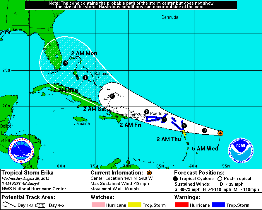
It said that at 500 AM today, the centre of Tropical Storm Erika was located near latitude 16.1 North, longitude 56.0 West.
“Erika is moving toward the west near 18 mph, and a west to west-northwestward motion at a slightly slower forward speed is expected over the next 48 hours. On the forecast track, the centre of Erika will move near or over portions of the Leeward Islands tonight and move near the Virgin Islands on Thursday,” the bulletin said.
“Maximum sustained winds are near 40 mph with higher gusts. Some slow strengthening is forecast during the next 48 hours. Tropical storm force winds extend outward up to 105 miles from the centre. The estimated minimum central pressure based on data from a NOAA Hurricane Hunter aircraft is 1003 mb,” it stated.
Expected impacts on land
According to the DDM, sustained winds up to 30-35 mph with gusts to 50 mph are possible late Thursday in the heaviest thunderstorms. Scattered power outages are possible.
It said that rainfall amounts may accumulate up to 3 to 5 inches but that storm surges are unlikely to exceed 1-2 ft.
Take preparatory action
Speaking to this news site today, Information and Education Manager at DDM Philomena N. Robertson said the expected impacts for the VI based on current projections from various meteorological sources are heavy winds, upwards of 45 mph and heavy rainfall and thunderstorms.
“The Department of Disaster Management encourages all residents to ensure that preparedness actions are taken. Preparedness increases the ability to cope in the event of hazardous impact, thus it is important to continuously strive for a level of preparedness when faced with impending hazards,” she said.


.png)


.png)


.png)


50 Responses to “UPDATE: ‘All clear! It’s back to work!’ – says NEOC”
A litte energy won't kill ya. But bad Scotch will.
Rather safe than sorry. Look what could have happened. The department is doing the best it can with the info they receive. What responsibility are you taking to be prepared?
Every time I leave this place you people turn it up side down. If it isn't man made it is nature crying out. Just wait, this storm will not come close to the hurricane which will follow the Congress meeting of the VIP in a few days time. Just wait and see.
How could a department be so wrong so many times. Bad information could not only cause loss of life but loss of business. The DG is old and bordering on se*n*le its high time she vacate that post. DDM needs restructuring from the top down and staff with more educated and competent people. This can't continue to happen it should be stop right now.