


.jpg)


VI calls on UN to fulfill mandate of decolonisation of last colonies
MANAGUA, Nicaragua- The Virgin Islands (VI) has called on the United Nations (UN) Special Committee on Decolonisation (C24) to take meaningful steps in fulfilling its mandate to support the decolonisation of the 17 remaining Non-Self-Governing Territories (NSGTs) at the Special Committee’s recently concluded Caribbean regional seminar on decolonisation that took place in Managua, Nicaragua.

‘It's been special'- Donyelle D. Hodge on her reign as Miss BVI 2025
ROAD TOWN, Tortola, VI- Miss BVI 2025 Donyelle D. Hodge has called her reign special.

UPDATE: Tola are 2026 King of the Court Caribbean Champions!
ROAD TOWN, Tortola, VI- Tola (Tortola) are $30,000 richer and boast the title of 2026 King of the Court Caribbean Champions, after defeated a game St Thomas, 74-67, in the Championship Game at Multi-Purpose Sports Complex on Sunday, June 7, 2026.

Climate change, derelict vessels & seabed approvals in State of Territory Address- Deputy Premier
ROAD TOWN, Tortola, VI- Deputy Premier and Minister for Environment, Natural Resources and Climate Change, Hon Julian Fraser, RA (R3) has encouraged residents to tune in for the State of the Territory Address on Tuesday, June 9, 2026.

Premier Wheatley wants claims for Anegada lands to be settled 'quickly'
THE SETTLEMENT, Anegada, VI- The Premier of the Virgin Islands, Dr the Honourable Natalio D. Wheatley (R7), has expressed commitment to having the longstanding Anegada lands issues, dating back to 1885, be settled as quickly as possible.

Hon Luce D. Hodge-Smith named CTO's Minister/Commissioner of Tourism of the Year
New York, USA – Honourable Luce D. Hodge-Smith (R4), the Junior Minister for Tourism and Culture for the Virgin Islands, has been honoured with the title of Minister/Commissioner of Tourism of the Year at the Caribbean Tourism Organisation's (CTO) third annual Caribbean Women in Tourism Leadership Awards.

Lesmore Smith honoured @Virgin Islands Pride Awards in New York
THE BRONX, New York, USA- Local businessman and horse owner Mr Lesmore Smith was honoured with two prestigious Awards at the Virgin Islands Pride Awards Dinner and Dance Awards Ceremony held in The Bronx, New York, on May 17, 2026.

2 dead, 2 injured after early-morning shooting @Luna Bar on St Croix
VI CONSORTIUM
FREDERIKSTED, St Croix, USVI— Two people are dead and two others are receiving treatment after an early-morning shooting at Luna Bar on St Croix, the Virgin Islands Police Department confirmed Sunday, June 7, 2026.

Works continue on lighting system project @ A.O. Shirley Recreation Ground
ROAD TOWN, Tortola, VI- Piling works for the final two lighting poles for the Lighting System Installation Project at A.O. Shirley Recreation Ground have now been completed, and the foundations for these poles have been successfully cast.

VI beat Bonaire 2-0 in international friendly in Spain
MALAGA, Spain- The Virgin Islands bounced back from their 4-0 defeat to Gibraltar on Wednesday to blank Bonaire 2-0 in their international friendly in Spain on Saturday, June 6, 2026.

Merger of BVIEC & W&SD 'a transformative step'- Hon Kye M. Rymer
ROAD TOWN, Tortola, VI- The legislation to merge the BVI Electricity Corporation (BVIEC) and the Water and Sewerage Department (W&SD) has successfully received the approval of the House of Assembly and was assented to by Governor Daniel Pruce.

Farmers & fishers urged to prepare this hurricane season
ROAD TOWN, Tortola, VI- The Department of Agriculture and Fisheries is encouraging farmers and fishers to prepare for the 2026 Atlantic Hurricane Season which began on June 1, 2026.

USVI: Man facing federal charges after hundreds of rounds of ammunition found in luggage
VI CONSORTIUM
CHARLOTTE AMALIE, St. Thomas, USVI- A man is facing a federal charge after Customs and Border Protection officers found hundreds of rounds of ammunition in two checked suitcases that arrived in St. Thomas on an American Airlines flight from Miami.

Poetry & critical Essay Writing Competition launched
ROAD TOWN, Tortola, VI- A poetry and critical essay writing competition as part of activities to observe the Commemoration of the 250th Anniversary of Freedom at Nottingham Estate, Long Look has been launched. The competition is being hosted by the Ministry of Tourism, Culture and Sustainable Development in collaboration with the Long Look 250th Commemorative Committee.
.png)
58 naturalised as BOTs citizens
ROAD TOWN, Tortola, VI- Fifty-eight persons were naturalised as British Overseas Territories citizens on Friday, May 29, 2026, during a Naturalisation Ceremony held at Government House.
_22.jpeg)
King & Queen Crossover
By Dickson C. Igwe
This investigative writer aims to adopt the culture of the criminal investigator in deciding who will win the Virgin Islands General Election in a number of months. His use of micro dots or tiny data points as the foundation of his assessments is in keeping with that culture. He next looks for links between the dots.

Excellence in Customer Service CXC Programme launched in VI
ROAD TOWN, Tortola, VI- Dr Eduardo R. Ali, the Pro-Registrar and Deputy Chief Executive Officer of the Caribbean Examination Council (CXC), has praised the launch of the Excellence in Customer Service CXC Programme in the Virgin Islands as a significant step towards transforming public service.

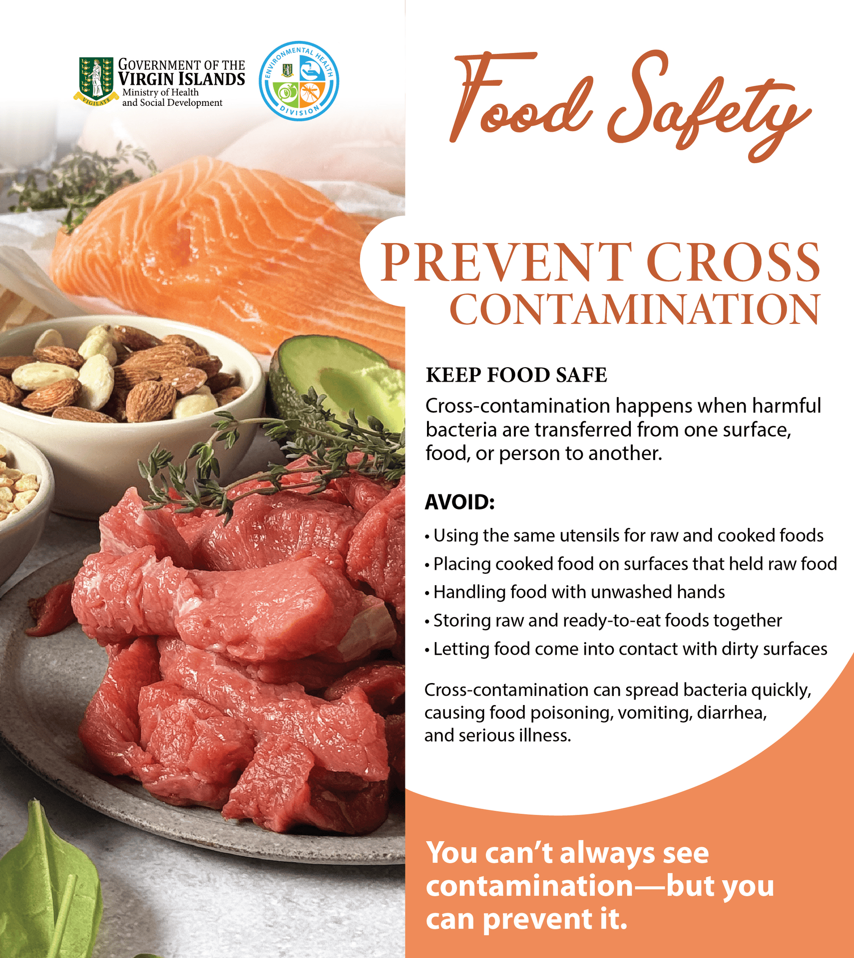
Cleaning & sanitation the 'biggest problems'- Environmental Health Officer
ROAD TOWN, Tortola, VI- Environmental Health Officer Susan Sealey has identified cleaning and sanitation as one of the major concerns for the department. Her comments came ahead of World Food Safety Day, which is being celebrated globally on June 7 to raise awareness about the dangers of contaminated food.

Judge hears domestic violence allegations against ex-USVI senator Janelle K. Sarauw
VI CONSORTIUM
FORT LAUDERDALE, Florida, USA — A Broward County judge on Thursday, June 4, 2026, heard hours of sharply conflicting testimony in the final hearing of a domestic-violence injunction case filed against former Virgin Islands senator and current Delegate to Congress candidate Janelle K. Sarauw, with the matter set to continue Friday afternoon and a ruling possible before the end of the day.

Mary Joseph is VI’s new Junior Ambassador of Tourism
ROAD TOWN, Tortola, VI- Mary Joseph, a student of the BVI Seventh-day Adventist School, is the Virgin Islands’ (VI) new Junior Ambassador of Tourism.

‘Proactive steps’ being taken this hurricane season- Hon Kye M. Rymer
ROAD TOWN, Tortola, VI- Minister for Communications and Works, Hon Kye M. Rymer (R5) has called on residents of the Virgin Islands (VI) to renew their commitment to preparedness, vigilance and collective responsibility, as the 2026 Atlantic Hurricane Season commenced on June 1, 2026.

VI crowned Champions of CTO Regional Nex-Gen Tourism Showcase
NEW YORK, USA- The Virgin Islands team, consisting of Adrianne Thomas, Auri-Ana El Shabaz, and Naomi A. Onwufuju from H. Lavity Stoutt Community College (HLSCC), has been named the champions of the 2026 CTO Regional Nex-Gen Tourism Showcase.

Shakhoy Penn charged with possession of illegal firearm & ammo
ROAD TOWN, Tortola, VI- Shakhoy Penn, 29, of Scatliffe Alley, Tortola, has been charged with Possession of a Prohibited Firearm and Unlawful Possession of Explosives.

VG Bayside Blazers blow out St Croix on Night 2 of 2026 King of the Courts
ROAD TOWN, Tortola, VI- After falling to St Thomas, 96-88, on the opening night of the 2026 King of the Courts Caribbean Basketball Championship on Tuesday, June 2, 2026, VG Bayside Blazers rebounded handsomely to crush St Croix 100-79 on Wednesday, June 4, 2026, at Multi-Purpose Sports Complex.

2026 Miss BVI Pageant contestants to feature in 'Crown & Conversations' this evening
ROAD TOWN, Tortola, VI- Following the Miss BVI 2026 contestant reveal on May 29, 2026, the Miss BVI Sub-Committee has announced ‘Crown & Conversations’ where the public will have the opportunity to learn more about the three contestants.

‘We will hunt you down’- Detective Inspector to distributors of edibles
ROAD TOWN, Tortola, VI- “You are not going to use them [young people] as targets to sell your drugs so that they can end up in prison and you outside here enjoying all the luxuries of what you are using them for.” This is according to Detective Inspector Kendolph A. Bobb of the Family and Juvenile Unit in the Royal Virgin Islands Police Force (RVIPF).

‘Health infastructure & derelicts' are priorities for Health Ministry- Hon Vincent O. Wheatley
ROAD TOWN, Tortola, VI- Minister for Health and Social Development, Honourable Vincent O. Wheatley (R9), has expressed hope that the Premier will address two main priorities for his ministry during the upcoming State of the Territory Address.

‘Ya’ll don’t know what to do? Hire me’- Pastor Claude O. Skelton-Cline
BAUGHERS BAY, Tortola, VI- Pastor and social commentator Mr Claude O. Skelton-Cline has warned Virgin Islanders to beware of a pending energy lockdown.

UPDATE: VI fall 4-0 to Gibraltar in football friendly in Europe
EUROPA POINT, Gibraltar- They were favoured to win against Gibraltar; however, the Virgin Islands were blanked 4-nil by the hosts in their international football friendly at Europa Point Stadium on Wednesday, June 3, 2026.

The 'continued exploitation' of police officers 'will no longer be tolerated'- PWA
ROAD TOWN, Tortola, VI- “The continued exploitation of officers through delayed compensation, unresolved salary disparities, and prolonged administrative inaction will no longer be tolerated.” This is according to the Police Welfare Association (PWA) in a statement on June 2, 2026, titled: Police Welfare Association Demands Immediate Action on Pay Inequities, Non-payment of Allowances, Regularising Acting Appointments, and Systemic Administrative Failures.

RVIPF offering $50K for info leading to capture of Jose Almestica & John M. Burgos
ROAD TOWN, Tortola, VI- The Royal Virgin Islands Police Force (RVIPF) is offering a reward of fifty thousand dollars ($50,000) each for information leading to the successful capture and arrest of two escaped fugitives, Jose Almestica and John M. Burgos, both residents of the United States Virgin Islands.

VI must implement policy to manage AI- Hon Lorna G. Smith, OBE
ROAD TOWN, Tortola, VI- Junior Minister for Financial Services and Economic Development and Digital Transformation, Hon Lorna G. Smith, OBE, (AL), has said the Virgin Islands (VI) must equip itself with a policy to manage Artificial Intelligence (AI).

BVICC hosting Meet the Members Series on June 4, 2026
ROAD TOWN, Tortola, VI- The BVI Chamber of Commerce invites you to our Meet the Members Series happening across the Virgin Islands.

‘Do something! How are we going to eat?' Claude O. Skelton-Cline to Gov't
BAUGHERS BAY, Tortola, VI- Social commentator and host of Honestly Speaking, Pastor Claude O. Skelton-Cline, has said the Virgin Islands (VI) is currently facing a crisis with food insecurity, being a country fully dependent on imports.

‘The Virgin Islands has lost a builder'- VI Premier on passing of Collingston George
ROAD TOWN, Tortola, VI - The Premier of the Virgin Islands, Dr the Honourable Natalio D. Wheatley (R7), has expressed deep sadness over the passing of Mr Collingston George, whom he regarded as a distinguished leader in Virgin Islands business and a dedicated Virgin Islander who contributed immensely to the country.

VI & USVI rugby teams clash @A.O. Shirley Recreation Grounds this weekend
ROAD TOWN, Tortola, VI- BVI Rubgy will host USVI Rubgy’s Privateers in a 1st and 2nd team match-up on Saturday, June 6, 2026, at the A.O. Shirley Recreation Grounds in Road Town.

BVI Finance 2026 Roadshow heads to Latin America in July
ROAD TOWN, Tortola, VI- Following the postponement of the Latin American leg of its roadshow, BVI Finance has announced it will now be held in July 2026.

2026 Atlantic Hurricane Season opens with below-normal forecast
VI CONSORTIUM
FREDERIKSTED, St Croix, USVI- The 2026 Atlantic hurricane season began on Monday, June 1, 2026, with forecasters calling for a quieter-than-usual year, but federal and university outlooks continue to stress a point familiar to the Caribbean and the U.S. Virgin Islands: even a below-normal season can produce one storm capable of changing lives, damaging infrastructure and disrupting entire communities.

International & regional tourism leaders attending 2-day summit in VI next week
PETER ISLAND, VI- The Virgin Islands is set to host a Tourism Summit aimed at bringing together various stakeholders in the tourism industry, including leaders, entrepreneurs, investors, policymakers, and creatives.

'I was in the hospital flatlining'; J'versatile calls on youth to stay away from drugs
ROAD TOWN, Tortola, VI- Singer and Songwriter, Jan Williams, aka J'versatile, the 2023 Virgin Islands Soca Monarch, has urged the youth of the territory to stay away from drugs after experiencing a life-threatening situation following the ingestion of marijuana edibles.


.png)


.jpg)


Follow Us On
Local News
Recent Comments
- Curious on VI calls on UN to fulfill mandate of decolonisation of last colonies
- BIG G on ‘We will hunt you down’- Detective Inspector to distributors of edibles
- Raw and Unfiltered on VI calls on UN to fulfill mandate of decolonisation of last colonies
- mehnknow on Premier Wheatley wants claims for Anegada lands to be settled 'quickly'
- BALI 5.4 on Miss BVI 2026 contestant ‘saddened’ by low participation numbers

