

UPDATE: Tropical Storm Danny further weakening
Danny has become more disorganised since the previous advisory.
The centre of circulation is now exposed and environmental conditions will remain unfavourable as Danny tracks toward the northeastern Caribbean. Due to a recent southwest shift in the track, forecasters have adjusted the projected path further south. As a result, the overall forecast implications for the northeastern Caribbean is less wind and slightly less rain than indicated in the previous forecast.
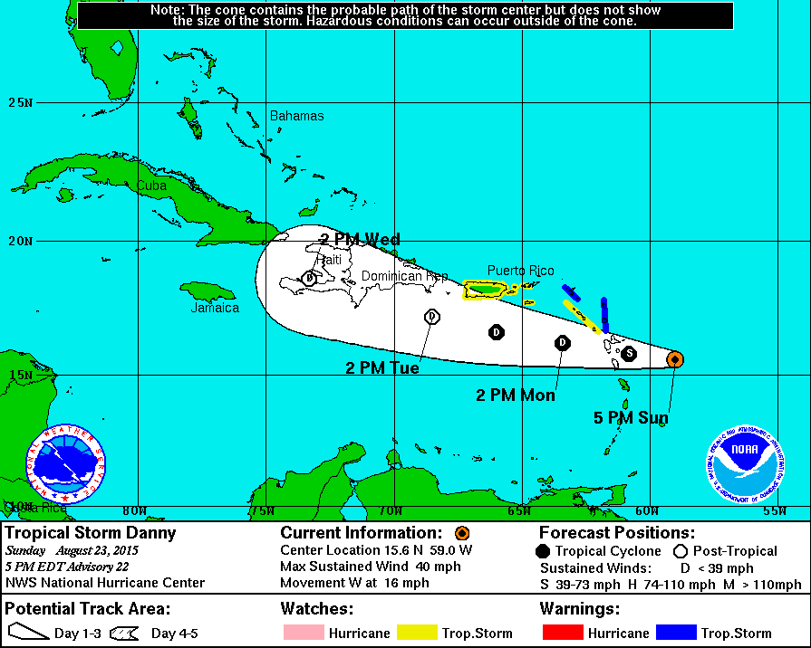
At 5:00 p.m., the centre of Tropical Storm Danny was located near latitude 15.6 degrees north, longitude 59 degrees west. Danny is moving toward the west near 16 miles per hour (mph). A westward to west- northwest motion is expected over the next 48 hours.
Maximum sustained winds have decreased to 40 mph with higher gusts. Tropical storm force winds extend outward up to 60 miles. Continued weakening is expected during the next 48 hours and Danny is expected to become a tropical depression on Monday.
The estimated minimum central pressure is 1006 mb.
Expected Impacts on Land
On the forecast track, the centre of Danny is expected to move near or over portions of the Leeward Islands late tonight or early Monday and into the northeastern Caribbean Sea on Monday.
Tropical Storm Danny should be in the vicinity of the BVI tomorrow with increasing cloudiness, strong gusty winds, showers and thunderstorms. The winds could cause some isolated power outages.
Rainfall
Heavy rain could cause localised flooding by late Monday and early Tuesday. Widespread significant impacts are not expected.
Storm Surge
No significant tidal surge is expected.
Residents of the British Virgin Islands are advised to monitor the system as it progresses and keep abreast of updates issued by the Department of Disaster Management.
See previous press release published August 22, 2015
Hurricane Danny downgraded to Tropical Storm
Danny has officially been downgraded to a tropical storm by the National Hurricane Center.
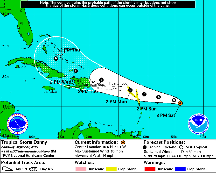
Tropical Storm Danny has been rapidly deteriorating on satellite imagery over the past 6 hours and currently maximum sustained winds are 65 mph.
It is likely that Danny will weaken more quickly than previous forecast indicated.
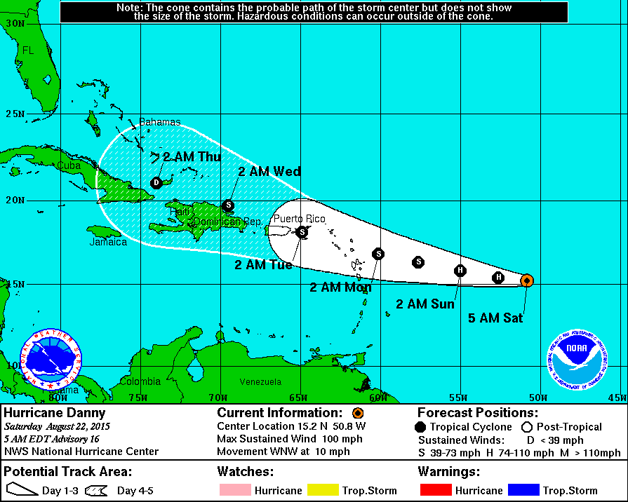
Danny will likely only be a weak tropical storm (at most) when it reaches the Leeward Islands.At 8:00 p.m., the centre of Hurricane Danny was located near latitude 15.6 degrees north, longitude 54.1 degrees west. Danny is moving toward the west near 14 miles per hour (mph). This general motion is expected through Monday.
Maximum sustained winds remain near 65 mph with higher gusts. Tropical storm force winds extend outward up to 60miles. Additional weakening is forecast during the next 48 hours. The estimated minimum central pressure is 997 mb.
Expected Impacts on Land
On its present track, Hurricane Danny is expected to be near or over the British Virgin Islands late Monday and could impact the Territory with sustained winds of around 35 -45 mph. Peak gusts of around 60 mph are possible.
Large battering waves are expected during the passage of Hurricane Danny. Seas will peak near 12 feet. Mariners will need to seek safe anchorage for their vessels.
RainfallThe first squalls are likely to reach the area on Monday afternoon. General rainfall amounts of 3 to 6 inches are expected through Tuesday afternoon.
Higher amounts are likely in the mountains. The Antigua Meteorological Service advises that moderate flooding could occur and a flood watch or warning may be required for Monday.
Some landslides are possible. Road conditions could deteriorate and motorists should exercise caution.
Storm Surge
A tidal surge of 1 to 3 feet is possible along the coast accompanied by large waves. Some beach erosion is likely.
Residents of the British Virgin Islands are advised to monitor the system as it progresses and keep abreast of updates issued by the Department of Disaster Management.


.png)
.png)


.png)


4 Responses to “UPDATE: Tropical Storm Danny further weakening”